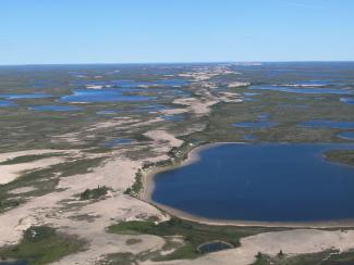
A Vancouver Island University (VIU) research project will provide a unique opportunity to examine the glacial landscape of Canada’s North, leading to new mapping methods that will help people identify sources of sand, gravel or minerals.
Canada’s North is rich in natural resources and a major driver of economic growth in the region. Large mineral deposits could include diamonds, gold, silver, copper and other base metals.
VIU Professors Dr. Jerome Lesemann (Earth Science Department) and Dr. Brad Maguire (Geography Department), with the help of Yiqing Luo, a VIU Master of Geographic Information Systems (GIS) Applications student, are being funded by Natural Resources Canada (NRCAN - Earth Sciences Sector) to assist in the development of better remote predictive mapping (RPM) methods aiding exploration.
Mapping of surficial materials is an integral component of development in northern Canada. “Traditional methods of surficial mapping, employing aerial photographs and field verification, are both time-consuming and expensive,” says Maguire.
Lesemann and Maguire’s research project aims to develop a methodology for computerized detection of the sediment components of eskers, ridges of gravel and sand which occur in formerly glaciated regions of northern Canada.
“Eskers are ubiquitous glacial landforms, formed in ice tunnels made by water flowing under the ice sheets. The long-winding ridges of stratified sand and gravel are some of the most abundant and accessible sources of aggregates for infrastructure growth needed for road building in northern regions,” says Lesemann. “And they are prime sampling targets for commodities like diamonds.”
Currently, RPM is a promising avenue of semi-automated mapping using widely available digital datasets like multispectral satellite imagery. “However, there are gaps in the methodology,” says Lesemann. “Part of the problem is that the type of imagery used to date gives us information about spectral characteristics of the surface, which reflects mostly the type of material on the surface, like bedrock or sand and gravel. The imagery does not contain information about the three-dimensional shapes of landforms.”
Using newly available digital terrain models, landforms like eskers can now be identified and mapped in great detail. The team is developing a methodology to automatically detect and map these landforms. The VIU project team proposes to develop an esker element detection methodology based on Deep Machine Learning (a form of Artificial Intelligence) supported by a Convoluted Neural Network (CNN). CNN uses computer algorithms to try and replicate complex cognitive processes of the human brain.
“We will be using CNN to identify eskers from newly available, high-resolution digital elevation models (DEM) of the Canadian Arctic,” says Maguire
Lesemann says the aim is to train a computer to recognize patterns, similar to the way our brain, through experience knows that when we look at a dog, we know it’s a dog and not a cat even though they share some similarities but also key differences.
“The form and structure of eskers are complex and if we can teach a computer to learn what an esker looks like, we may then be able to identify other eskers automatically.”
“This approach is needed because there are millions of square kilometres of Canada where the landforms have not been mapped in sufficient detail to identify them properly,” adds Maguire.
The project is funded by a $35,000 research grant provided by the NRCAN Geo-Mapping for Energy and Minerals (GEM) program, a 12-year initiative to significantly advance and modernize geological knowledge in the North to support increased exploration of natural resources and inform decisions on land use and responsible resource development.
“This is a significant Canadian undertaking with many partners, and it’s exciting for us to contribute to our understanding of past ice sheets and to the development of improved mapping methods,” says Lesemann.
-30-
About the Research Team:
Jerome-Etienne Lesemann (PhD) is a Professor in the Earth Science Department at Vancouver Island University. He specializes in glacial and quaternary geology. He has experience in reconstructions of glacial history and glacial processes, mineral exploration in glaciated terrains, and remote sensing in the context of Remote Predictive Mapping in glaciated terrains of Canada. He has worked on glacial landscapes and sediments of all major paleo-ice sheets (Laurentide, Cordilleran, and Fennoscandian) and in modern glacial settings in Iceland and Greenland. An area of expertise deals with reconstructions of glacio-hydraulic processes and inferring deglacial dynamics from landforms such as tunnel valleys, meltwater corridors and eskers.
Brad Maguire (PhD), is a Senior Instructor in the Masters in GIS Program at Vancouver Island University. He specializes in geomatics and the automated detection of landforms from digital terrain models. He has experience developing workflows and methodologies integrating Neural Networks and Terrain Modeling to extract key morphometric variables capable of characterizing glacial landforms such as drumlins and eskers.
MEDIA CONTACT:
Annette Lucas, Communications Officer, Vancouver Island University
O: 250.741.2020 | C: 250.618.7296 | E: Communications@viu.ca


